Next: Operating the TNG Data Handling and Archiving
Up: Archiving
Previous: The Indexing of the SDSS Science Archive
Table of Contents -
Subject Index -
Author Index -
PS reprint -
McLean, B. J., Greene, G. R., Lattanzi, M. G., & Pirenne, B. 2000, in ASP Conf. Ser., Vol. 216, Astronomical Data
Analysis Software and Systems IX, eds. N. Manset, C. Veillet, D. Crabtree (San Francisco: ASP), 145
The Status of the Second Generation Digitized Sky Survey and
Guide Star Catalog
B. J. McLean, G. R. Greene
Space Telescope Science Institute, 3700 San Martin Drive,
Baltimore, MD 21218
M. G. Lattanzi
Osservatorio Astronomico di Torino, Strada Osservatorio 20,
I-10025 Pino Torinese (TO), Italy
B. Pirenne
ESO/ST-ECF, Karl-Schwarzschild-Strasse 2, D-85748, Germany
Abstract:
The STScI is continuing its program to create data products and tools to
increase the efficiency of observation planning and telescope operations.
These include an long-term commitment to digitize, and distribute to the
community, the second generation Schmidt plate surveys for both the
Northern (POSS-II) and Southern (SES) hemispheres as an extension to the
published Digitized Sky Survey (DSS).
In addition to providing the images, STScI is leading a consortium
to create a second version of the Guide Star Catalog (GSC-II) which
will be used for both ground and space-based telescope operations.
While the original Guide Star Catalog (GSC-I) was developed with the goal
of increasing the efficiency of telescope operations and observation
planning for HST, this catalog and its companion, the Digitized Sky
Survey CDROM set (DSS-I), have proven to be key revolutionary tools to
modern astronomy. The Catalogs and Surveys Branch of the STScI, which
created and published the GSC-I and DSS-I (Lasker & Cannon 1990,
Russell et al. 1990, Jenkner et al. 1990), has been working to provide
second-generation versions of these products. Another set of more
recent all-sky survey plates is being digitized at STScI, and the recent
advances in computer technology have allowed us to process these images
and create a much larger catalog of astronomical objects than before. A
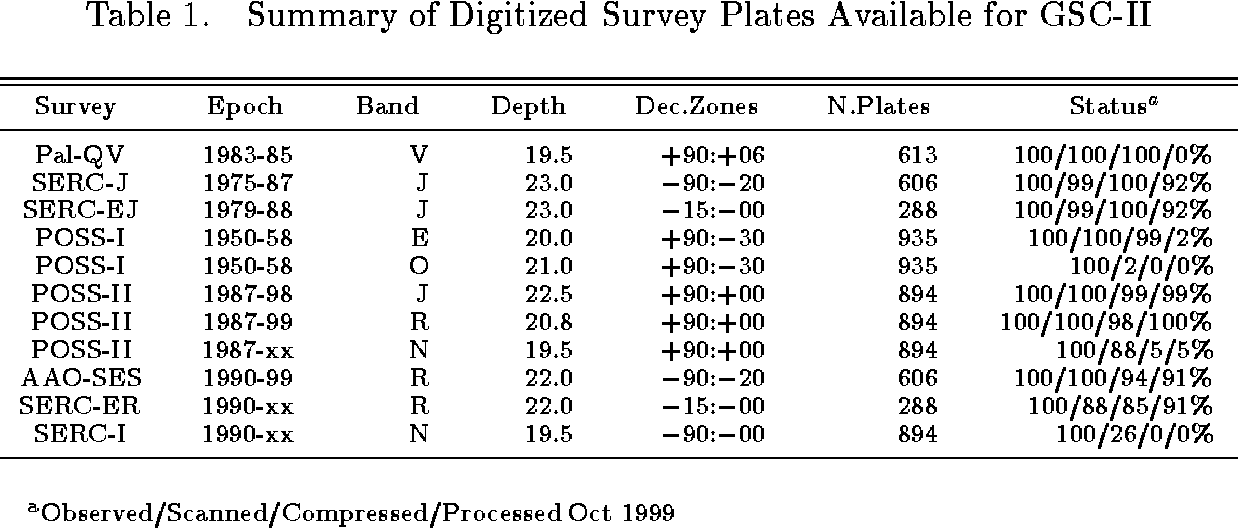
summary of available plate material and our current status is shown in
Table 1.
Recognizing the importance of these products for telescope operations
and planning tools, a number of international partners are collaborating
with us and supporting our efforts with the DSS-II and/or GSC-II projects.
These include OATo, ESO, GEMINI, ESA/ST-ECF, ESA/SA, CADC, CDS, AAO, NAOJ, BAO.
A preliminary release of the GSC-II will be provided to the GEMINI and
VLT telescopes at the end of this year, while an improved
version with better calibrations will be made available to the community
at the end of 2000.
The originally published Digitized Sky Survey consisted of the Palomar
POSS-I E survey
and the SERC-J survey scanned at 25 micron resolution with modified PDS
microdensitometers (Laidler et al. 1994). These have been substantially
redesigned and modified
to be multi-channel laser scanning machines and we are now
scanning the additional plate material at 15 microns.
STScI has negotiated access to the original plates of the POSS-II survey, and
in partnership with the Anglo-Australian Observatory (AAO) undertook the
Second Epoch Southern (SES) survey with the UK Schmidt (Lasker &
Cannon 1990). In addition, we have begun scanning the SERC-I plates so that
we will have the entire sky in at least 3 passbands (J, F, IV-N) and a
sufficient baseline to determine proper motions.
These data are being compressed using the same HCOMPRESS algorithm
(White & Postman 1992) used for the
published DSS-I and made available on a number of web servers around
the world. The J and F bands are nearing completion and the I band will be
completed by 2001. A decision on the
format of a final distribution will depend on community interest.
The GSC-II extends the GSC-I to fainter
magnitude limits and consists of multiple epochs and bandpasses.
These add significant value to the original catalogue by providing
the necessary components to derive colours and proper motions for
most objects. This all-sky catalog will contain an estimated 2 billion objects
and will be complete to a magnitude of at least J=18 and as faint
as J=21 at high galactic latitudes. These data are being loaded into an
object-oriented database which is designed to allow easy recalibration
of the data as better algorithms and data models are developed.
The formal goals of the GSC-II are as follows:
- At least 2 epochs and passbands over entire sky,
- Limiting magnitude at least 18 (plate limited where possible),
- Positional accuracy 0.15 arcsec,
- Proper motion errors 5-20 mas /yr,
- Magnitude errors 0.2 mag,
- Classifications 95%.
Interim data deliveries (GSC 2.1.x) will be supplied for telescope operations
over the next year whilst the final calibrations are derived and applied.
The first general community release (GSC 2.2) will occur around the end of
2000, with a final version available (GSC 2.3) a year later. The published
version of the catalog will be exported from our object database
(described in section 4) as binary FITS tables for each HTM region on the sky
(approximately 1 square degree). Access software to read entries from this
distribution format has already been developed and integrated into a number of
tools including ESO SKYCAT and STScI SEA.
We have developed an object-oriented database, COMPASS
(Catalogs of Objects and Measured Parameters from All-Sky Surveys),
built on the kernel of Objectivity/DB commercial system.
This database is now into full production with the loading and
cross-matching of catalogue data derived from image processed
Schmidt photographic plates. There are clear advantages to
object-oriented technology. Firstly, the hierarchical kernel of
Objectivity easily scales to the estimated 4 TB of plate
observations we intend to archive. Secondly, an oo database
provides a very efficient methodology for establishing relationships
between the variable physical representations of the stored observations
and associated metadata. The primary utilization of the database is
to provide rapid access to plate data for advanced astrometric and
photometric calibrations as well as multi-plate operations that will
yield colours and proper motions. The calibrations depend on the
ability to do large scale transactions on many plates at a time to
remove well-known systematic errors that are inherent to photographic
plates. With this requirement, we have developed access methods to
COMPASS that will allow global updates to all calibrated plate parameters.
Our other goal in the design of COMPASS is to promote database
interoperability between GSC-II and other astronomical archives.
Following the reasoning of having manageable amounts of data of
roughly the same quantity as in the GSC-I custom database,
the sky is partitioned into approximately equal areas using the
Hierarchical Triangulated Mesh (HTM), a quad tree based on a
spatial subdivision of the celestial sphere into approximately
equal area spherical triangles (Barrett 1995). Each of the triangular
subdivisions corresponds to an Objectivity database within the
all-sky Federated database. This strategy has also been adopted
by the SDSS Science Archive and 2MASS and is an ideal example for
supporting interoperations between large-scale astronomical archives.
The HTM can serve as a common identification basis for any user or
agent selected spatial region of the sky. Within each triangular
region database we are creating several containers: one for each
plate to store the measured and calibrated parameters for each
source; a container for each astronomical catalog with reference
sources; and an Index container which has derived multi-plate
parameters and links references to the same source in the plate
and catalog containers. There will typically be 5-8 observations
of the same source measured on different plates, and each plate
will be split up among 50-60 region databases. Depending on the
nature of the query, we can easily retrieve sources grouped by
plate or region after determining the appropriate list of region
databases containing the sources. Access to the source parameters
is achieved by iterating over the index in each region database,
retrieving the derived data or using the references to directly access
the raw data from the individual plates.
At this time, most of the Digitized Sky Survey images are available via the web
and we are continuing to scan the remaining available plates. Production
processing of the images for construction of the GSC-II is also well advanced,
and database operations are in progress.
We expect to complete both of these projects within the next 18-24 months, and
expect them to be as useful to the community as the original datasets.
References
Barrett, P. 1995 in ASP Conf. Ser., Vol. 77, Astronomical Data Analysis
Software and Systems IV, ed. R. A. Shaw, H. E. Payne, & J. J. E. Hayes
(San Francisco: ASP)
Jenkner, H., Lasker, B. M., Sturch, C. R.,
McLean, B. J., Shara, M. M., & Russell, J. L.
1990, AJ, 99, 2081
Lasker, B. M., & Cannon, R. D.
1990 Proceedings of Digital Sky Surveys,
Bull. Centre de Données Stellaires, no.37, p13,
Jaschek and MacGillivray (eds)
Laidler, V. G., Greene, G. R., Ray, K., Evzerov, A.,
& Lasker, B. M.
1994 BAAS27.01
Lasker, B. M., Sturch, C. R., McLean, B. J.,
Russell, J. L., Jenkner, H., & Shara, M. M.
1990, AJ, 99, 2019
Russell, J. L., Lasker, B. M., McLean, B. J.,
Sturch, C. R., & J. L., & Jenkner, H.
1990, AJ, 99, 2059
White, R. L. & Postman, M.
1992 Proceedings of Digitized Optical Sky Surveys,
MacGillivray and Thomson (eds)
© Copyright 2000 Astronomical Society of the Pacific, 390 Ashton Avenue, San Francisco, California 94112, USA
Next: Operating the TNG Data Handling and Archiving
Up: Archiving
Previous: The Indexing of the SDSS Science Archive
Table of Contents -
Subject Index -
Author Index -
PS reprint -
adass@cfht.hawaii.edu